Carnac
"a megalithic wonderland"
Aubrey Burl
see panoramas of the alignments - at Ménec and Kermario
The small town of Carnac in southern Brittany is world-famous for the long rows of standing stones stretching over a mile or so in a north-easterly direction to the north of the town. Much plundered in centuries past for stone and generally getting in the way of earlier generations, these fabulous relics gained greater respect over the 20th century, and are now under State protection.
Finding your way about
Nothing can really prepare you for the sight. While stone rows are known elsewhere, such as the Merrivale stone rows in Dartmoor, England, they just aren't on the stupendous scale seen at Carnac. The area is also surrounded by a wealth of menhirs, dolmens, passage graves, making the town well worth a visit if you're interested in megalithic sites. Carnac is also blessed with an excellent beach and the Quiberon peninsula nearby caters for all sorts of sports like wind-surfing and sailing. Take a look at the staying there section for more information as to where to stay, relative to the stones and other amenities.
If actually getting to the stones is important for you then you might want to know that (at 2001/2002) low season was October 1st to April 1st. It's worth calling the Carnac Tourist Office what the current situation is here as it varies year to year.
To see the alignments you can pick up a free map from the tourist office which shows the alignments and local roads. That's all you need to locate the Carnac alignments and about a dozen of the major local sites. For more detail he map you need is the 0821 OT Top 25 map from IGN, titled Presq'île de Quiberon, Auray, Carnac. Completists might consider the 0921 OT Vannes/Golfe De Morbihan for the few stones around Locmariaquer but the few major sites on that sheet are easy to find from normal tourist maps.
Tour of the sites near Carnac
Le Ménec
 It makes sense to start with the alignments, of
course, which takes between half a day and a day depending on your pace. See the map below for a general overview of the alignments. Unfortunately access
is restricted, particularly in the summer, to reduce erosion of the site. Most people
drive out of town, following the sign to the alignments which takes them to the massive
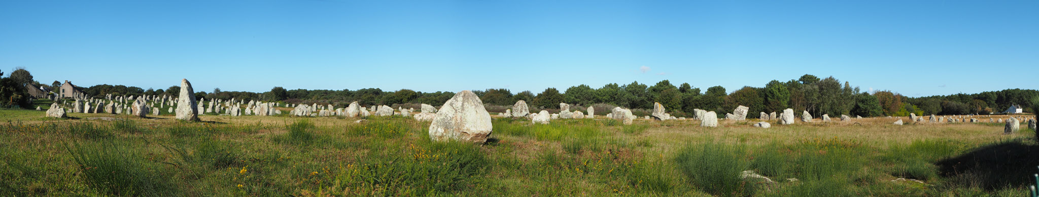
car park south of the Le Ménec alignments. The panorama above is
from there, though you have to go little bit further to see them
from that angle. It's worth trying to do this earlier in the day, as it gets very popular
since it is the closest to town and the place most people go if they want a quick look-see
of what all this fuss about alignments is about before getting on with the rest of their
activities.
It makes sense to start with the alignments, of
course, which takes between half a day and a day depending on your pace. See the map below for a general overview of the alignments. Unfortunately access
is restricted, particularly in the summer, to reduce erosion of the site. Most people
drive out of town, following the sign to the alignments which takes them to the massive
car park south of the Le Ménec alignments. The panorama above is
from there, though you have to go little bit further to see them
from that angle. It's worth trying to do this earlier in the day, as it gets very popular
since it is the closest to town and the place most people go if they want a quick look-see
of what all this fuss about alignments is about before getting on with the rest of their
activities.
If you are going to drive along the alignments there's something to be said for coming from north-east to south west instead - you're on the right side of the road as the alignments, and the two smaller car parks at Kerlescan and Kermario are handy right hand turns after the bend rather than awkward left-hand turns across the road before the bends...
Carnac-plage is into the cycle hire business in a big way, from standard mountain bikes to big all-family affairs which people seem to have great fun with. The higher point of view of a bike (above the infernal fence!) and the more leisurely pace plus being able to stop where you fancy has a lot going for it. since so much is within three or four miles of the town.
 Assuming you carry on the standard route, carry on NE
to Kerabus (just after you cross the main road, and this one is busy, being the main
Carnac to Auray highway and the way most long-distance traffic comes into the town).
There's no formal parking, but the lie of the land is nice and you can look over the
smaller alignments there.
Assuming you carry on the standard route, carry on NE
to Kerabus (just after you cross the main road, and this one is busy, being the main
Carnac to Auray highway and the way most long-distance traffic comes into the town).
There's no formal parking, but the lie of the land is nice and you can look over the
smaller alignments there.
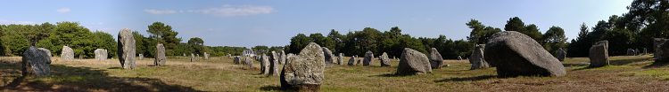
Kermario is your next stop, with a large-ish visitor car-park on the left just as the road turns to the right, which is a dodgy manoeuvre for UK visitors as the French drive on the right. Old-timers will recall the massive wooden platform where you could look over the alignments but all that has gone now, and there is an information building behind the stones. That does mean you get a better view of Kermario allée couverte, nestling at the corner of this alignment. A nice touch is they have placed a path to an old mill in the Kermario alignments at the north-eastern half which you can climb and get a better overview.
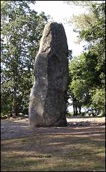
Next stop is Kerlescan - basically if you get to see the alignments from your car you've gone too far, as the small car park is just before the horse riding school, on your left before a bend to the left. It's also worth taking the forest trail for 500 yards to say hello to the Géant du Manio. Take the largest path going past the horse grazing fields, and the Géant is signposted on a turning west. It is the largest standing menhir in the area, 6.5 m high, and nearby is a rectangular-ish enclosure of stone, the Quadrilateral.
Petit Ménec
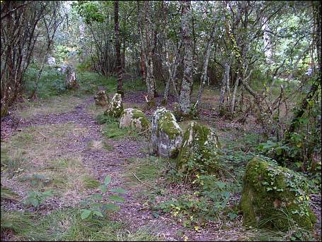
a row of moss-covered menhirs in the forest at Petit Ménec
Most visitors think they're done with the alignments at this stage, though if the light is right the enchanting stones in the forest of Petit Ménec are a magical addition to the tour. Here, you come across moss-grown rows of menhirs on the forest floor.
Because the paths criss-cross the forest at various angles, an illusion makes them appear to be laid out in short rows seemingly at random, but they do follow a gentle curve WSW to ENE.
History
Current thinking is that the alignments were constructed incrementally, with succeeding generations adding to the alignments over the centuries. Dating the rows is vexatious, since little organic matter is available. Burl indicates [41] about 3300 BC, with an error of several hundred years.
Restoration - James Miln and Zacharie le Rouzic
Though it is romantic to ponder the triumph of Neolithic engineering holding sway, keeping the thousands of stones upright across five thousand years of weather, some more recent help was needed. Every megalithic site on this grand scale inspires, and just as Avebury inspired Aubrey, Stukely and Keiller, so Carnac inspired its recent heroes. First was the Scottish antiquarian, James Miln. He excavated many sites at Carnac - not just the stones but also the Roman camps and antiquities. Yet it was the stones that were old when the Romans camped at Carnac inspired him -
..one is tempted to ask how it is that the Romans, masters of the world, came and disappeared, whilst the race of the rude constructors still remains..."
 Miln hired a local boy,
Zacharie Le Rouzic to carry his materials with which he drew the results of his
excavations. Through assisting Miln with his work, le Rouzic gained a passion for the
Carnac alignments and archaeology, and in the 1930s le Rouzic re-erected many of the
fallen stones, placing them as true to the original location as he could. Ever a careful
worker, le Rouzic indicated which stones had been reset with a tiny plug of pink cement at
the base, so that future workers would not be confused between the restored and the
original.
Miln hired a local boy,
Zacharie Le Rouzic to carry his materials with which he drew the results of his
excavations. Through assisting Miln with his work, le Rouzic gained a passion for the
Carnac alignments and archaeology, and in the 1930s le Rouzic re-erected many of the
fallen stones, placing them as true to the original location as he could. Ever a careful
worker, le Rouzic indicated which stones had been reset with a tiny plug of pink cement at
the base, so that future workers would not be confused between the restored and the
original.
Miln died in 1881, leaving the results of his work to the town of Carnac, and his brother established the James Miln Museum there. Likewise, Le Rouzic left his collection to the town, and these artifacts form the basis of the Carnac museum of prehistory in the town centre, which is well worth a visit (English speaking visitors will find it worth borrowing the folder with the English translation of the captions of the exhibits).
Alexander Thom
In 1969 Alexander Thom was invited to prepare a detailed survey of the Carnac alignments. Since they consist of more than 3000 menhirs spread over a distance of about 2½ miles this was no small undertaking. The father-son team of Alexander and Archie Thom worked from 1970 to 1974, drafting highly detailed 1:1000 plans of the alignments. These showed that what to the casual eye look like parallel rows stretching into the distance have random fluctuations in the lines of stones. The result, perhaps, of the gradual accumulation of the site as successive generation added to the work of their forebears
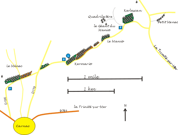
Map showing the alignments in relation to Carnac and the major roads
Other nearby sites
| Keriaval
| Mane Kerioned | St-Pierre Quiberon alignments |
| Quiberon peninsula | Pierres Plats | Le Grand Menhir Brisé |